


What are simmering issues for post-GE14?
(Read our summary of high-key issues for GE14 here.)
Bread-and-butter economic issues are regarded as front of mind for the average voter. We covered some of this in our Johor case study, examining the cost of living and housing affordability; with a comparison of a Johor Bahru (urban) household versus a Bukit Tinggi (rural, Felda) household. You should also look at Bank Negara’s concerns and call for a living wage.
So what else might urban-centric voters (and activists) feel some concern about? We look at the simmering issues of governance relating to land development and water in select hot button states, with a special focus on the Peninsular and case studies of Kedah and Kelantan.
First, we look at an an indicator of land activity for 2013-2016 across three states - Johor, Kedah and Kelantan. The greatest land activity (as a ratio of total district area) was in Pendang, Gua Musang and across several districts of Johor. This indicator covers both development and redevelopment economic activities. Heightened land (re)development-clearance should bode well for future incomes, but may cause some short to medium-term discomfort. Urbanites may face delays due to construction and be worried about rising congestion, rural folk may have regular incomes disrupted if there is major oil palm replanting (it takes a few years to mature) and Orang Asli may face local water supply problems and other impacts including minor landslides affecting road access.
After several years of El Nino-driven dry seasons (when the Peninsular was affected by drifting haze form peat smog and forest fires from Sumatra), it seems that the climatic turn to a regular-wetter situation brings on more flood risk. When this encounters major land development-clearance activities, we run into the Politics of Floods.

Land activity by district 2013-2016, as a proportion of land area - for three states
Development and water
In contrast to high politics, these issues are in the realm of low politics, and are localised or sub-regional issues. There are cases of resistance to rising urban density, water supply outages and extreme events like major flood crises. Malaysia NGOs typically blame deforestation (land clearing) for unusual flooding, as do various experts. In Thailand’s mega floods, the situation was similar, with the problem blamed on development, bad planning and officials, despite expert ambivalence on causality. What is common in various countries post-flood is a crackdown on logging and deforestation.
In the wake of the 2017 massive floods in Penang and Kedah, the Institution of Engineers Malaysia calls for a new comprehensive planning: "the master plan should include the flood mitigation and prevention action plans, for current and future developments, land use changes as well as climatic change factor."
Selected issues:
In the Klang Valley, Selangor has been beset by water supply issues for over a decade. In some areas, residents worry about the conversion of parks to property projects, including in Taman Rimba Kiara and Taman Desa, congestion problems during peak hours, and over-development.
Social activists points to a Penang (development) Dilemma; and concern about environment-development issues, notably about (real estate) hillslope developments and disgruntled residents. During rainy periods, small landslide risk is of concern. (However, there does not seem to be major risk concern as there is better engineering implementation on Malaysian hillsides.) Amidst local finger-pointing, Penang leaders argue that a freak storm and flood was politicised a few months ago.
Pahang issues include polluting aluminium mining that faced a ban (with exceptions), and an (anti-corruption) seize-and-release case. Earlier, a rare earth processing plant by Lynas of Australia caused concern and is likely to be an ongoing issue given the traumatic history of Mitsubishi's rare earth processing in Perak (with USD100 million voluntarily spent on its clean-up). Logging risks will first immediately affect the water source for villagers, and nature spots like Tasik Chini have been spoilt by various activities.
In Kedah, concerns have arisen on logging and sand mining, and seem to persist. There is concern about its effect on the water supply to the three northern states of Peninsular Malaysia, with some finger pointing between the authorities of Penang and Kedah.
Kelantan’s Orang Asli living near Gua Musang were affected by logging and durian plantation development, also giving rise to some blockades. The flood of 2014 was record setting (bankers tell of the first floor of bank branches entirely engulfed and planters talk of 15-20 meter tall oil palm trees submerged) and triggered by exceptional rain, but experts point to the problem of deforestation.
In Sabah, there is a electoral promise of better wildlife protection.
Fiscal federalism
Stronger state finances are often linked to increased land development (which state administrations fully control). It is regularly noted that Malaysian states rely on revenues from land related activities. Malaysia’s centralised federalism is criticised for a fiscal federalism that needs a fairer and more balanced distribution of revenue collection. At the Federal level, there is notable rising funding to the Prime Minister’s Office, with a large discretionary (development) spending portion and centralised control over even more. Budget experts note that this is often mirrored at the state level, with Chief Ministers having control over large discretionary budgets too, with little to distinguish BN and non-BN run states.
A lawmaker points out that only 2.4% of federal revenue goes back to states. Nevertheless, after the massive flood of 2014, Kelantan has been criticised for over-reliance on funding via concessions and logging. Activists ask its government to find other sources of revenue. Within the bounded context of state finances, it is clear that there is still an expectation that states have better governance and non-land revenues.
Perspectives on development
Land development includes extensification of economic activity with logging and timber plantations depending on the type of forest zones; intensification with forest conversion to agriculture, and agricultural land conversion to non-agriculture; and hyper intensification with upward revised plot ratios for high-density urban landscapes. It also covers large infrastructure projects (E.g. East Coast Rail Link, Pan Borneo Highway) and land reclamations (quite in vogue for large development projects in Penang, Melaka and Johor).
We spoke to 20 expert observers of land development issues (including three civil servants, whose views are featured in Appendix 1) with a semi-structured questionnaire. The key findings are shown in Table 1.a, and displays across-the-board concern about land governance, with a slightly positive view on economic outcomes, and strongly negative views on environmental and socio-economic impacts. Table 1.b presents observers views on policy reforms needed and indicates their economic sector and work geography.

Table 1.a: Views on land development projects - timing, governance, impact
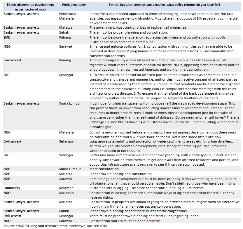
Table 1.b: Views on land development projects - policy reforms needed
Land development in Kedah and Kelantan - exploring big data and state budgets
In a preliminary review of land development by extensification, we set geospatial information (satellite imagery on zones of land clearance or tree cover loss for all types of economic development) against public information from state budgets (looking at non-recurring land-related revenue, that is most closely associated with such land development). Figure 1 shows that Kedah gets 50-60% of its revenue from land-related segments and Kelantan’s reliance has dipped to about 30%.
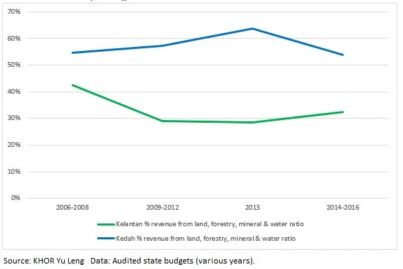
Figure 1: Kedah and Kelantan % state revenue from land, forestry, mineral and water
Note: Based on official audit reports that features top revenue sources, but do not provide the full breakdown of items. These figures will be slightly lower than the full count, as there will be some revenue amounts that are not shown in the “top” sources list.
Data on tree cover loss should give a fair gauge of land development, but only after we deflate it for the probable ratio of replanting of plantations in Malaysia (using recent national averages); to avoid inflating perceptions on deforestation. In this way, we derive a proxy for greenfield development (land clearance), from two data-sets available on the popular Global Forest Watch platform. Data on land clearance is not provided by states in a timely and comprehensive way. This approach offers an insight to economic analysis opportunities from including novel “big data” sources.
We reckon the above estimates on proxy data results in a conservative (perhaps underestimated) view for Kelantan given that is still a frontier of development (notably in the west and south-west). It should be relatively fair for Kedah which is a long developed state where forest-to-land conversions occurred decades ago (but there is recent activity around the water catchment areas in the north-east). However, with more resourcing a more detailed data study can distinguish true green-field development outside of long-in use areas, and these results should be updated accordingly.
Figure 2 illustrates adjusted data from Global Forest Watch on annual land clearance across a span of 10 years (grouped for apparent up-and-down cycles) for Kedah and Kelantan. The latter may recently have land clearance (ex-plantations) of over 12,000 hectares per year; which appears significantly higher than similar activity in Kedah (dark green versus blue columns).
Figure 2 and Figure 3 show the zones of land clearance-development activities (black-green) for each state that have occurred outside areas that were already in-use by 2000. (This data differs from the Global Forest Watch data referred to above that are used in Figure 4).

Figure 2: Map, Kedah - zones of land clearance

Figure 3: Map, Kelantan - zones of land clearance
The results of matching estimates of land clearance (from Global Forest Watch data sets) against state revenue, the indicative Ringgit per hectare suggests that Kedah reports significantly higher income per unit of land cleared (outside of plantation zones) is shown in Figure 4.
This preliminary review focuses on readily available and timely public information, which are the state revenues. It does not include income that government-linked corporations (GLCs), including Menteri Besar Incorporated (MBI) units, Yaysans (foundations) and others may earn off state land development activity. Further research should cover these data sources. For now, we may note that Kedah reports more in state revenue per hectare of land (development) clearance than does Kelantan (dark blue line versus the light green line in Figure 4). However, it is possible that Kelantan just books more of its land activity earnings elsewhere (in the aforementioned state-linked and other associated entities), but this needs to be clarified by an aggregate disclosure of such information.

Figure 4: Kedah and Kelantan - exploring public data on land (clearance) development and revenues
For the sake of improved transparency and governance (an issue strongly felt by the experts interviewed for this paper), it would be important that state administrations evolve to disclose comprehensive and timely information about land (development) clearance and what the state earns from (each hectare of) such activity.
Major findings:
Malaysia’s fiscal federalism centralises funding control in the center. At the Federal level, there is notable rising centralised control; and a similar pattern is seen at the state level, with Chief Ministers having control over large discretionary budgets too.
There are some obvious risk-gaps between the land development pace set by state administrations and “downstream” planning changes controlled at the Federal level. This results in blame-games between states and the Federal Drainage and Irrigation Department (E.g., Penang blames underspending) and causes states afflicted by record floods to appeal for Federal emergency relief (E.g., aid for the massive 2017 Penang flood). Kelantan faced massive floods in 2014, and experts point to the state’s search for revenue (from logging) and call for a stop to unsustainable land clearance, and better Federal-state cooperation.
We spoke to over 60 close observers of land development issues (including 20 experts and three civil servants). There was across-the-board concern about land governance, slightly positive views on economic outcomes, strongly negative views on environmental and socio-economic impacts. All observers were vocal about policy reforms needed, no matter which political coalition runs the state. There is a broad call for greater transparency and public consultation.
States can do better to report in a comprehensive way their earnings from land development. This is currently spread across State Budget and other entities such as state-level state-owned enterprises or GLCs (including Menteri Besar Incorporated) and state and other associated Yayasans (foundations).
Khor Yu leng is an independent geo-data economist at Khor Reports - Segi Enam Advisors.
This preliminary report builds on the research findings from the author’s interviews with 60 sources in late 2017 to early 2018, including those with state and budget specialists. Assisted by Jeamme Chia for geospatial data analysis and Sharon Tan for expert opinions on development issues.
#Malaysia #PRU14 #GE14 #PoliticalEconomy #Development #Flood #Governance #Deforestation #GlobalForestWatch #KhorReports #Data #DataScience
(c) 2018, Khor Yu Leng. All rights reserved.
Appendix 1: Viewpoints from three civil servants on governance in land development
Three civil servants in Peninsular Malaysia were among a group of expert observers on land development issues interviewed in late January to early February 2018. Among the often heated narratives of businessmen, NGOs and politicians, this segment often lacks a voice; and so we present their views here verbatim.

